Field Surveying 
Central to understanding the variability
in crop and pasture production is an assessment of soil
characteristics. Terrabyte Services routinely uses EM31/38
surveying to develop targeted soil investigation strategies
that assist with identification of soil and potential management
zones.
Surveying typically involves collection
of data at 5m intervals along transects spaced at between
10m and 50m depending on the agronomic application. Data
is supplied in both hardcopy and GIS digital format for
display and management by most farm mapping software.
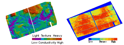
EM Survey and soil investigations have
successfully identified conductivity trends that correlate
with both physical and chemical characteristics in a range
of landscapes. Significantly, variability in yield maps
and crop imaging is often closely matched to the patterns
identified in EM Survey maps. EM Surveying is also widely
recognised as a highly effective means of mapping dry land
and irrigation salinity.
| Apparent Conductivity - EM38 |
Remote Sensing
- NDVI |