Electromagnetic Surveying
Overview 
Much of the variability observed in agricultural
systems can be attributed to variability in soil properties.
Understanding the nature and extent of this variability
can lead to improved management and better matching of landuse
to land capability.
EM surveying has been shown to be a rapid,
cost efficient method of generating information, that together
with follow up ground truthing can provide accurate maps
of soil type differences and distribution.
Electromagnetic surveying measures the
soils apparent electrical conductivity, which is influenced
by a number of soil factors including porosity, soil moisture,
the concentration of dissolved electrolytes and amount and
type of clay.
The maps are used to identify trends
within the survey area and to target locations for further
soil investigations to determine the nature of the variability.
With a unique survey system, Terrabyte simultaneously uses
an EM-38, EM-31 and RTK GPS to assess soils to depths of
1.5m and 1.6m while collecting high accuracy elevation data.
EM surveying has a proven track record
in mapping of soil characteristics related to:
For agronomic applications, the
linking of EM data with additional information such as
remote sensing, yield mapping or other spatially referenced
data, is proving a rapid and cost effective method for
identification of production or management zones.
Utilising EM technology, managers and
agronomists are able to quantify and locate the extent of
variability underlying their production system. Subsequent
targeting of soil and crop monitoring is then able to more
accurately determine the range of productive potential and
to adjust management accordingly.
Click on images to view enlargement

EM31/EM38 mounted on a
Landcruiser |
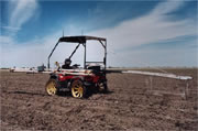
EM31/EM38 mounted on a quad
bike
|
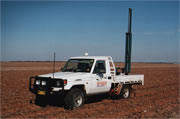
Soil Sampling Equipment mounted
on a Landcruiser |